
Geology MAUI App: Cross-Platform Field Assistant
Project Overview
The Geology MAUI App is a cross-platform mobile application built with .NET MAUI, designed to assist geology enthusiasts in collecting, organizing, and analyzing geological data in the field. This project represents a revival of an old Windows Phone concept, now brought to life with modern cross-platform technology.
Core Objectives
- Field Data Collection: Enable GPS-tagged geological sample logging and field observations
- Offline Capabilities: This is never going to work so drop this as an aspiration
- Educational Tool: Provide learning resources for anyone with an interest in geology and fossils
- **Make it accessible to my target audience of teenagers and up.
Technical Stack
Primary Technologies
- .NET MAUI: Cross-platform framework for iOS, Android, Windows, and macOS
- C#: Primary programming language
- XAML: User interface markup language
- SQLite: Local database for offline data storage
- MVVM Pattern: Architecture pattern for separation of concerns
Supporting Libraries
- Microsoft.Extensions.DependencyInjection: Dependency injection container
- CommunityToolkit.Mvvm: MVVM helpers and utilities
- SQLite-net-pcl: SQLite ORM for .NET
- Microsoft.Maui.Essentials: Cross-platform device APIs
- Mapping Libraries: (Under evaluation - considering MapBox, Esri, or OpenStreetMap solutions)
- Resend: Setup resend to handle emails sent from the app - primarily error reports and suggestions.
Architecture
Application Structure
GeologyApp/
├── ViewModels/          # MVVM ViewModels
├── Views/               # XAML UI Views
├── Models/              # Data models and entities
├── Services/            # Business logic and data services
├── Data/                # Database context and repositories
├── Platforms/           # Platform-specific implementations
└── Resources/           # Images, fonts, and other assets
Data Architecture
The app uses a layered architecture approach:
- Presentation Layer: XAML views with MVVM pattern
- Business Logic Layer: Services for geological calculations and data processing
- Data Access Layer: SQLite database with Entity Framework Core (If needed, not implemented so far November 2025)
- Platform Services: GPS, camera?
Key Features
1. Sample Collection System
- GPS Integration: Automatic location tagging for all samples
- Photo Documentation: Multiple photos per sample with metadata (optional later build)
- Field Notes: Rich text notes with geological observations (optional later build)
- Classification System: Standardized rock and mineral classifications used Notes on classification systems 17/10/2025 - Note most of this is still to be implemented, the classification system is a big task and I am still working on the database schema for this.
2. Offline Mapping (Functionality dropped November 2025)
Cached Maps: Download geological maps for offline useSample Plotting: Visualize collected samples on mapsRoute Tracking: Record field survey routes- Geological Overlays: Display geological formations and fault lines Geological maps UK 17/10/2025 - Note I am still evaluating mapping solutions, MapBox seems to be the best option for offline use but it is not free for larger scale use. OpenStreetMap is free but lacks geological data overlays. This is still a work in progress. With the exception of the display of geological formations this is still to be implemented. Also going to need an account and access at BGS
3. Mineral Identification - Future Version (Unlikely November 2025)
- Decision Trees: Interactive identification workflows
- Visual Guides: Photo libraries of common minerals and rocks
- Property Database: Physical and chemical properties reference
- Streak and Hardness Tests: Digital tools for field testing
4. Data Management - Future Version
- Export Capabilities: CSV, JSON, and KML export formats
- Cloud Sync: Optional cloud backup and synchronization
- Collaboration: Share findings with team members
- Backup and Restore: Local backup functionality
Development Progress
Phase 1: Foundation (Current)
- Project setup and architecture design
- Basic MVVM implementation
- [] SQLite database schema design
- Core navigation structure
- GPS integration testing
- Basic UI implementation
Phase 2: Core Features
- Sample collection workflow
- Photo capture and management
- Basic mapping integration
- Classification system implementation
Phase 3: Advanced Features
- Offline map caching
- Mineral identification system
- Data export functionality
- Cloud synchronization
Phase 4: Polish and Distribution
- iOS App Store deployment
- Google Play Store deployment
- User testing and feedback integration
- Performance optimization
Technical Challenges
iOS Development Complexity
One of the biggest surprises returning to mobile development has been the complexity of iOS deployment:
- Apple Developer Account: Required $99/year subscription
- Mac Hardware Requirement: Absolute necessity for iOS development
- Certificate Management: Complex provisioning profile and certificate workflow
- App Store Review Process: Lengthy approval process with strict guidelines
Cross-Platform Considerations
- Platform-Specific UI: Adapting to iOS and Android design guidelines
- Performance Optimization: Ensuring smooth operation on various device capabilities
- File System Differences: Handling platform-specific storage limitations
- GPS Accuracy: Dealing with different GPS implementations and accuracy levels
Geological Domain Complexity
- Classification Standards: Implementing standardized geological classification systems
- Scientific Accuracy: Ensuring geological information is scientifically sound
- International Standards: Supporting different regional classification systems
- Complex Relationships: Modeling complex geological relationships in database
- Access to Data: Ensuring easy access to geological data for users especially in offline scenarios and non-UK regions
AI-Assisted Development
This project serves as my second major collaboration with AI development tools (following the NHS Trawler project). The AI assistance has been particularly valuable for:
October 2025 Update
So I thought it was time for an update on the Geology MAUI App project. After a few months of development, here’s where things stand: Lessons learned, what’s working, and what’s still a challenge. The logic of the app is coming together, but there are still some hurdles to overcome, but AI definitely helped with this, however where it struggles is the higher level design and UX, it can do the logic code bit but not so much the overall design. An example of this is white text on a white background, clearly it needs some kind of visualization pipeline. It’s still early days for AI pair programming, but I do think it has a future. I spent a lot of time trying to get the text in the app menu to have good legibility in different lighting conditions, which is important for field use. When I say a lot of time I mean a couple of weeks of my dev time, switch to investigating myself and a couple of hours sorted it. The downside of this is the code that AI generates is not always optimal and can be dense so you do need to review and refactor it, indeed finding it can be difficult.
Current position as of October 2025: I have what would be a minimum viable product for the geology app, with the core features of geological history information, light and dark themes. Basically the free app. Next is more robust error handling and and advertising to help fund the project.
An early iteration of the advertising module caused loads of errors, lots of them were not correctly handled and this led to a re-structure of the error handling in the app. This is now much more robust and should handle most scenarios. I also added a simple logging mechanism to help diagnose issues in the field and in order to help with user support. I also added a simple feedback mechanism to allow users to report issues or suggest features, which in turn required a new website backend to handle the feedback. This is just a skeleton at the moment, but it is a start with a new domain, fossilgeo.uk
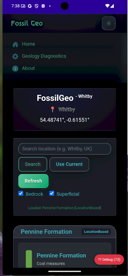
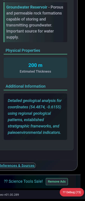
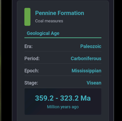
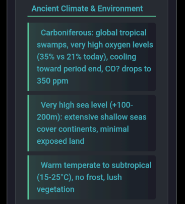
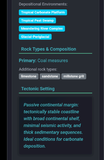
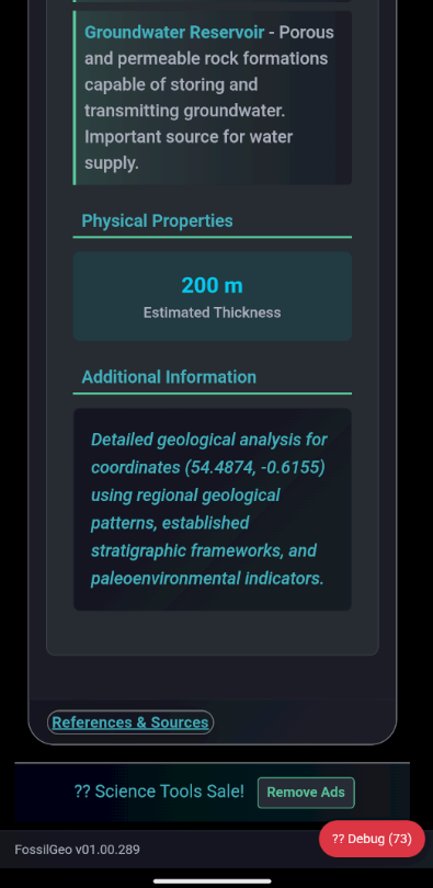
Screenshots for the Android App
the screenshots below show the current state of the app on Android, with geological information for the current location being displayed. The app is still in development, but it is coming together nicely. however there is still a lot of work to be done on the user experience and overall design. Note I have now registered a new domain for the project FossilGeo
Code Generation
- MVVM Boilerplate: Rapid generation of ViewModels and command implementations
- XAML Layouts: Assistance with complex UI layouts and styling, although often requiring refinement
- Database Models: Entity relationship design and SQLite schema generation
- Platform Services: Implementation of platform-specific functionality
Problem Solving
- Architecture Decisions: Evaluating different approaches to common mobile development challenges
- Performance Optimization: Identifying potential bottlenecks and optimization strategies
- Best Practices: Ensuring modern .NET MAUI development patterns
- Error Resolution: Debugging complex cross-platform issues
Database Schema
Core Entities
-- Sample collection points
CREATE TABLE Samples (
    Id INTEGER PRIMARY KEY,
    Name TEXT NOT NULL,
    Description TEXT,
    Latitude REAL NOT NULL,
    Longitude REAL NOT NULL,
    Elevation REAL,
    CollectionDate DATETIME NOT NULL,
    CollectorName TEXT,
    WeatherConditions TEXT,
    RockType TEXT,
    MineralContent TEXT,
    Notes TEXT
);

-- Photo documentation
CREATE TABLE Photos (
    Id INTEGER PRIMARY KEY,
    SampleId INTEGER,
    FilePath TEXT NOT NULL,
    Caption TEXT,
    TakenDate DATETIME NOT NULL,
    FOREIGN KEY (SampleId) REFERENCES Samples(Id)
);

-- Mineral identification data
CREATE TABLE Minerals (
    Id INTEGER PRIMARY KEY,
    Name TEXT NOT NULL,
    ChemicalFormula TEXT,
    HardnessMohs REAL,
    SpecificGravity REAL,
    CrystalSystem TEXT,
    Color TEXT,
    Streak TEXT,
    Luster TEXT,
    Description TEXT
);
User Interface Design
Design Principles
- Field-Ready: Large touch targets for use with gloves
- High Contrast: Visibility in various lighting conditions
- Minimal Input: Reduce typing requirements in field conditions
- Offline-First: All core functionality available without internet
Navigation Structure
- Home Dashboard: Quick access to recent samples and key functions
- Sample Collection: Step-by-step data entry workflow
- Map View: Geographic visualization of collected data
- Identification Guide: Mineral and rock identification tools
- Settings: App configuration and data management
Testing Strategy
Unit Testing
- Service Layer: Testing business logic and data services
- Model Validation: Ensuring data integrity and validation rules
- Utility Functions: Testing geological calculations and conversions
Integration Testing
- Database Operations: Testing SQLite data access patterns
- Platform Services: Testing GPS, camera, and file system integration
- Navigation: Testing MVVM navigation patterns
Field Testing
- Real-World Usage: Testing in actual geological field conditions
- Device Variety: Testing across different phone and tablet configurations
- Network Conditions: Testing offline capabilities and sync functionality
Future Enhancements
Machine Learning Integration
- Image Recognition: Automatic mineral identification from photos
- Pattern Recognition: Identify geological formations in photographs
- Predictive Analysis: Suggest likely mineral occurrences based on location
Collaboration Features
- Team Projects: Shared field projects with multiple contributors
- Real-Time Sync: Live collaboration on field surveys
- Data Sharing: Export and import capabilities for research collaboration
Educational Modules
- Interactive Lessons: Guided learning modules for geology students
- Virtual Field Trips: Augmented reality geological tours
- Quiz System: Knowledge testing and certification tracking
Advanced Mapping
- 3D Visualization: Three-dimensional geological modeling
- Stratigraphic Columns: Interactive stratigraphic section builder
- Fault Analysis: Tools for analyzing geological structures
Installation and Setup
Development Environment
- Visual Studio 2022: Latest version with MAUI workload installed
- Android SDK: For Android development and testing
- Xcode: Required for iOS development (Mac only)
- .NET 8.0: Latest .NET framework
Dependencies
<PackageReference Include="Microsoft.Extensions.Logging.Debug" Version="8.0.0" />
<PackageReference Include="CommunityToolkit.Mvvm" Version="8.2.2" />
<PackageReference Include="sqlite-net-pcl" Version="1.8.116" />
<PackageReference Include="SQLitePCLRaw.bundle_green" Version="2.1.6" />
Running the Project
# Clone the repository
git clone [repository-url]

# Restore NuGet packages
dotnet restore

# Build the solution
dotnet build

# Run on Android emulator
dotnet run --framework net8.0-android

# Run on iOS simulator (Mac only)
dotnet run --framework net8.0-ios
Contributing
This project welcomes contributions from the geological and development communities. Areas where contributions would be particularly valuable:
- Geological Expertise: Validation of classification systems and scientific accuracy
- UI/UX Design: Improving the user experience for field conditions
- Performance Optimization: Mobile performance and battery life improvements
- Testing: Field testing and bug reports from actual geological fieldwork
Project Status
Current Phase: Foundation Development Last Updated: September 10, 2025 Development Blog: Follow the development journey
Recent Updates
- Initial project architecture completed
- Database schema designed and implemented
- Basic MVVM structure in place
- GPS integration testing in progress
Upcoming Milestones
- Complete sample collection workflow implementation
- iOS development environment setup
- First beta release for internal testing
- Integration with mapping services
This project represents a fusion of modern mobile development practices with practical geological fieldwork needs. Follow along with the development process through the associated blog series for detailed insights into the challenges and solutions encountered during development.
License
This project is developed as open-source software to benefit the geological community and serve as a learning resource for .NET MAUI development.
Related Content:
- Development Journey Blog Post
- NHS Trawler Project - Another AI-assisted development project